NOAA Water Vapor Loops

I saw the animation below on California Weather Blog.   It’s produced by NOAA from GOES West imagery to illustrate atmospheric circulation of water vapor.  What caught my eye about this particular loop is the continental-scale evolution of the circulation.

wv-animated1

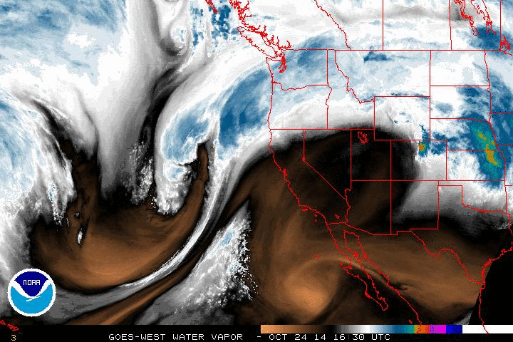
NOAA’s description of the color scale:

[Water vapor images are] taken using a wavelength sensitive to the content of water vapor in the atmosphere. Bright and colored areas indicate high water vapor (moisture) content (colored and white areas indicate the presence of both high moisture content and/or ice crystals). Black and brown areas indicate little or no moisture present. Water vapor imagery is useful for both determining locations of moisture and atmospheric circulations.

GOES West loops available here.

Truth in Advertising: Weather Forecasting Edition

I check the NWS forecast every morning.   I also check the “Forecast Discussion” section – where the forecasters give the details behind the forecast on the main page – because sometimes there’s something like this:

.NEAR TERM /UNTIL 6 PM THIS EVENING/...
***TODAY/S FORECAST IS OF VERY LOW CONFIDENCE GIVEN CONSIDERABLE
  MODEL DISAGREEMENT***

PRETTY REMARKABLE MODEL DISAGREEMENT FOR A 12 HOUR FORECAST.  THE
MODELS ARE STRUGGLING WITH A PLUME OF TROPICAL MOISTURE STREAMING
NORTHWARD FROM THE MID ATLANTIC STATES. WHENEVER YOU ARE DEALING
WITH TROPICAL MOISTURE AND VIRTUALLY NO THERMAL GRADIENT...ITS
GOING TO PLAY HAVOC WITH COMPUTER MODEL FORECASTS AND PLACEMENT OF
QPF.

AT THIS POINT...THE BEST THING WE CAN DO IS KEEP THE THEME OF THE
FORECAST GOING FROM THE LAST FEW DAYS...NOT JUMPING ON WILD MODEL
SWINGS...

Three cheers for truth in advertising.  Admission of uncertainty is a good thing.

Continue reading

Snow forecast

Snowfall forecast from the NWS Taunton office:

StormTotalSnowFcst-13Feb2014

If you click through the link above see also the “Probability [X] Inches of Snow” maps to the right of the Storm Total Snow Forecast Map.   (Useful information complementary to the map above and well-presented.)


California’s Drought: A little relief. How might the drought be related to climate change?

California has been experiencing its driest weather in potentially 500 years.  Fortunately, northern CA is finally getting some rain.  Here’s NOAA’s precipitation forecast for the continental US for Feb.7-12 (created on the afternoon of Feb.7).  “When it rains it pours.”  Note the predicted amounts for northern CA:

p120i-07Feb2014

The forecast precipitation won’t be nearly enough to break the drought (details below) but it’ll help.

The source of the moisture is an “atmospheric river”.  Continue reading