It is a fact that some image analysts are superior to other image analysts because they:
- Understand the scientific principles better,
- Are more widely traveled and have seen many landscape objects and geographic areas, and/or
- They can synthesize scientific principles and real-world knowledge to reach logical and correct conclusions.
Category Archives: Science
LearnEO!
LearnEO! is a creation of the European Space Agency. From the LearnEO! website:
LearnEO! is an Earth observation education project funded by the European Space Agency. Its aim is to increase the understanding of satellite data from ESA missions and show how these can be used to tackle environmental problems in the real world.
The project will develop hands-on training resources for use primarily (but not exclusively) by teachers and students at upper high school to university level.
NASA Applied Remote Sensing Training
From the NASA ARSET website:
The goal of the NASA Applied Remote SEnsing Training (ARSET) is to increase the utility of NASA earth science and model data for policy makers, regulatory agencies, and other applied science professionals in the areas of Health and Air Quality, Water Resources, Eco Forecasting, and Disaster Management.
The two primary activities of this project are webinars and in-person courses. Continue reading
What is the Madden-Julian Oscillation?
Local meteorologist David Epstein has a nice discussion of the medium-range weather forecast for the New England region on boston.com, January Will Arrive On A Cold Note. (His Weather Wisdom posts are very good in general.) El Nino and the Madden-Julian Oscillation (MJO) featured in his discussion. El Nino comes up pretty regularly in weather discussions but the Madden-Julian Oscillation? I’d never heard of it. From NOAA:
The Madden-Julian Oscillation (MJO) is a tropical disturbance that propagates eastward around the global tropics with a cycle on the order of 30-60 days. The MJO has wide ranging impacts on the patterns of tropical and extratropical precipitation, atmospheric circulation, and surface temperature around the global tropics and subtropics. There is evidence that the MJO influences the [El Niño/Southern Oscillation] cycle. It does not cause El Niño or La Niña, but can contribute to the speed of development and intensity of El Niño and La Niña episodes.
What I do
I’m always looking for better ways of explaining what I do to people who don’t have technical backgrounds. The video below provides a nice overview of remote sensing as a field and notes some environmental applications that researchers are addressing as well as the challenges they face as satellite-based Earth-observing sensors age past their design lifetime. (I don’t work environmental problems but set that aside for the time being. The methods available and approaches to information gathering that I use are essentially the same.)
New page: On the Environment
New page on the blog: On the Environment. I decided I needed to create a list of environment-related pieces that I keep going back to. I may add some of my own thoughts in the future but at present it’s just a bibliography.
Total recall
A piece in today’s NY Times reminded me of an article in the NYT Magazine and subsequent letter to the editor from nearly 20 years ago. It was concise and lucid. (Read the comments section from today’s piece to see why I was reminded.) I’ll adapt Kaplan’s letter for today’s times:
The 0.1% are part of a culture that values only the act of selling something for more than it was bought. When they and other like them are finished, they will, no doubt, have become more wealthy and more powerful. Yet they will have contributed so very little to the society from which they skim their profits. For all their talent, they offer nothing to the arts, nothing to the sciences and nothing to our shared stock of human ideas.
That’s it in a nutshell. From my standpoint, the super rich do little more than consume resources and generate huge piles of excrement. You want to understand my class hostility? There it is in one paragraph.
PS Dean Baker addresses Sorkin’s criticism of Sen. Warren here.
PPS A less angry take on compensation disparities and the super rich: Janna Malamud Smith, Toward A Better America: Readjusting The Value Of Low-Paid, High-Commitment Work. (I’m not a low-paid worker but I respect people who take on low-paid high-commitment work.)
Lewis Black on professional expertise, climate change, and acting responsibly
(Thanks to Eli Rabett for posting the video and his monologue in prose. He’s right. There is a rhythm to it.)
NOAA Water Vapor Loops
I saw the animation below on California Weather Blog. It’s produced by NOAA from GOES West imagery to illustrate atmospheric circulation of water vapor. What caught my eye about this particular loop is the continental-scale evolution of the circulation.
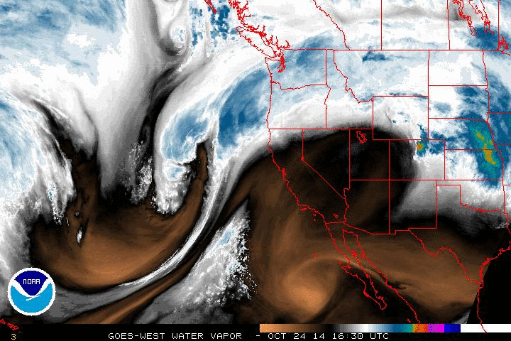
NOAA’s description of the color scale:
[Water vapor images are] taken using a wavelength sensitive to the content of water vapor in the atmosphere. Bright and colored areas indicate high water vapor (moisture) content (colored and white areas indicate the presence of both high moisture content and/or ice crystals). Black and brown areas indicate little or no moisture present. Water vapor imagery is useful for both determining locations of moisture and atmospheric circulations.
GOES West loops available here.
I think that the people at Digital Globe know what they’re doing
A colleague sent me a link to Digital Globe’s presentation at an “Investor Conference” last year. Yeah, I know, investor conference presentations are loaded with propaganda but I believe there’s considerable substance behind their charts. (Ever have the feeling you’re not working for the right company? No? Nah, me neither.)
PS Recall that Digital Globe is the company behind the WorldView satellites.